The exploration of Blackmoor Valley, and
|
 |
 |
 |
View along causeway from the west photo attributed to R Saunders |
Looking upstream towards Blackmoor Shaft photo T Elkin |
Detail from west photo T Elkin |
 |
Flood damage in Blackmoor and Velvet Bottom
From WCC Occ Pub: The Great Storm and Floods of July 1968 on Mendip |
Mr Brown of Hazel Warren Farm, Nordrach, reported that Thursday 11/07/68 was a fine day, attracting many people to Blackmoor Valley where the torrents of water provided a novel sight and an opportunity for paddling. The exposure of the washing-bed structures of the lead mine and the heaps of flood debris attracted numerous treasure hunters.
In the morning water still formed a flood running across Town Field from Blagdon Hill reaching the lower corner of the pond where outlet normally occurs. Water also crossed the road at the dip by Paywell Farm where chaff caught in the fencing indicated a depth of 1m. The pond itself was also 1m above its normal high water level. The stream continued on down the valley, overflowing the hollows below the Somerset Youth Centre hut at the junction with the valley from Charterhouse Manor Farm.
 |
 |
 |
Damage to the causeway. Looking upstream Photo attributed to Charterhouse Centre |
Looking upstream photo ?? |
Flood debris below the causeway photo ?? |
 |
 MCG Cottage, 2. Blackmoor Swallet, 3. Blackmoor Shaft, 4. Unmade track, 5. Charterhouse crossroad, 6. Charterhouse-Yoxter Road") |
WCC Occasional Publication
The Great Storm and Floods of July 1968 on Mendip Hanwell and Newson |
MCG Journal 1962
1. (Old) MCG Cottage, 2. Blackmoor Swallet 3. Blackmoor Shaft, 4. Unmade track 5. Charterhouse crossroad, 6. Charterhouse-Yoxter Road |
 |
 |
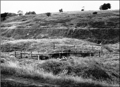
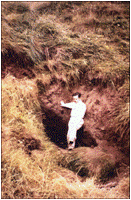
The entrance to Grebe Swallet, 1968
photos by ?? |
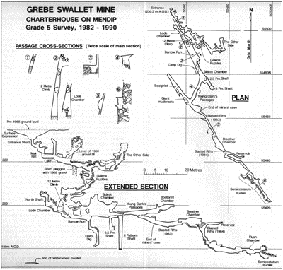
Grebe Swallet survey, WCC. Note the terminus of Waterwheel Swallet, bottom left on extended section |
Tom Elkins of the Somerset Education Committee Field Centre at Charterhouse actually watched the new swallet develop close to the road. This occurred on Thursday afternoon 11/07/68 when water gradually started to sink. Tom then removed some obstructions from the hole and the water rushed down. By the end of the day all the water went down the hole. Tom Elkins made a first exploration shortly after and decided to call the hole Grebe Swallet. MCG members Brian Hillman and Greg Smith went down on the following Monday followed by a party from UBSS on the same day. Greg and Brian found the cave as if un-entered, since the stream had obliterated evidence of earlier exploration. They called the cave Lower Flood Entrance. It is interesting to note that the new swallet developed close by a spot dug to about 2.5m in March 1961 by persons unknown.
Grebe Swallet is formed in a fault which crosses Velvet Bottom and which lies parallel to a series of partly mineralised faults running to ruined Bleak House and beyond. The cave appeared to have been almost entirely formed by flood excavation.
Considering the volume of material removed from the shakehole and cave, there was much speculation about the possible existence of a way large enough to allow rapid transport of debris. By 1976 the entrance had collapsed, and MCG efforts were being concentrated elsewhere. But the swallet was later reopened by Willie Stanton who discovered a lead mine connected to natural cave beyond.
 |
 |
 |
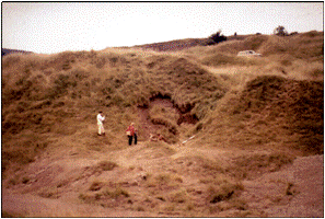
Subsidence in the bank below the unmade track, revealing Lower Middle Swallet photo M Cotter |
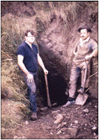
Simon Knight and Don Searle
Middle Flood Swallet photo M Cotter |
Don Searle
Middle Flood Swallet photo M Cotter |
 |
The entrance to this cave, which is immediately below the unmade track from the Charterhouse crossroad, was discovered by MCG member Arthur Cox on the weekend following the flood. His attention was drawn to the spot by the glooping sound emitted from within. On 27/07/68 MCG members Don Searle and Simon Knight cleared away subsidence of the bank and gained entry to a small cave about 9m long. A flat-out crawl of about 4m led to a chamber where they could stand up. In the floor of the chamber was a boulder choke, which on discovery contained numerous sods of turf indicating the direction of water flow. The entrance had a roof of boulders cemented by calcite and a passage leading to a chamber in massive limestone dipping towards the valley. The site was dug for several weekends and an air current was reported. However, it was Willie Stanton and the WCC who eventually made the breakthrough and explored the cave. |
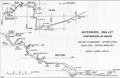
Survey of Waterwheel Swallet; WCC
North point to the left - the plan has been rotated to fit the page |
|
| Click to continue to next page |
or jump to:
| Back to top |
Page created 06 October 2009, last updated 14 February 2010 |
|
|
Mendip Caving Group. UK Charity Number 270088. The object of the Group is, for the benefit of the public, the furtherance of all aspects of the exploration, scientific study and conservation of caves and related features. Membership shall be open to anyone over the age of 18 years with an interest in the objects of the Group.