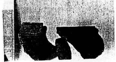
Mendip Caving Group Journal No 2 1960This html version was created by Martin Rowe © Trustees of the Mendip Caving Group 2010 THE MARQUESS OF BATHHis Lordship the Marquess of Bath has been kind enough to become the Group's Patron. We would like to take this opportunity of thanking him for this honour. We are also very grateful for his permission for the excavation of Cooper's Hole and the interest and constructive help he has given. COOPER'S HOLEby ROBBIE CHARNOCKSituation: - Cheddar Gorge 469540 Even in the 12th Century Writers referred to a hole at Cheddar 'where is a cavity under the earth which, though many have often entered and there traversed great spaces of land, and rivers, they could yet never come to the end.' This hole is not now known at Cheddar unless as suggested by H.E.Balch in his book Cheddar, its Gorge and Caves - it is Cooper's Hole. Further evidence that Cooper's leads to the underground stream is to be found. Before the road was tarred, lime-dust which was washed into Cooper's after heavy rain in the Gorge emerged at the spring head. For many years the caving fraternity on Mendip has looked on Cooper's Hole with envious eyes. The late Marquess of Bath was, however, adverse to allow excavation to be carried out on his property and hence Cooper's Hole has remained an unknown quantity. In 1931-32, R.F. Parry carried out an archeological excavation at the entrance and reached a depth of 15 ft without reaching the cave floor but no actual cave excavation was attempted. In the early part of this year our Secretary applied on behalf of the Mendip Caving Group to the present Lord Bath for permission to excavate Cooper's Hole. His Lordship granted this, much to our pleasure and the envy of other Mendip Clubs. Excavation started on March 14th when a pit was dug 6 ft by 2 ft and 4 ft deep. The upper layers consisted essentially of tins and broken glass and this made digging rather dangerous. It is surprising to note that during the whole time work has been carried out at Cooper's, no one has suffered badly from cuts. A fortnight later Easter Weekend digging was continued in earnest. The trial trench had partially collapsed and thus it was decided to dig a ramp angled at some 20 degs to the road level. The direction of the trench was S.S.W. The clay, earth, tins and broken glass were brought out on a sledge which Tony Crawford had constructed. This was pulled up in two ways, either by having several fellows pulling on a rope attached to the sledge or by having the rope through a pulley fixed to the wall in the entrance and attached to the front of the van forming a single Spanish Whip. The merits of these two methods were argued long and loud by their exponents resulting in each party using its own method. The trench progressed quickly and we were soon below ground level. About ten feet from the surface the soil was very fine and gritty. Three of us were working at the face when the sides collapsed and buried me up to the thighs. Fortunately (for me) I was soon dug out and although it was not serious we voted to stop digging for that evening. Below the layer of gritty earth was a thick layer of brown tenacious clay in which were numerous small pellets of black carbon presumably from the Charterhouse lead mines. In this clay we found bones, pottery and what we first thought were limestone axe heads but subsequently found out that they were only natural stone chips. The bones were examined by Professor Sutcliffe of the Natural History Museum who identified them as modern! We had much better luck with the pottery. This was taken to the British Museum and there it was identified as Iron Age B from about 1 AD. It consisted of several small pieces of black earthenware which had at one time formed the base, sides and rim of several pots. The pieces of rim were decorated with whirls and circles. All the pottery has been donated to Gough's Museum. In the late spring and early summer we had a great deal of rain and this all flowed down Cooper's, at any rate it seemed so to us, since each weekend we were obliged to bail out two or three feet of water before we could carry on digging. This was usually achieved with large biscuit tins which we found Unhappily these leaked a considerable quantity of water often ending in 'one up and two down', when their contents did reach the entrance it was surreptitiously emptied down the Gorge through the car park into Cheddar! On one occasion some of the members were tired of bailing by hand and went to seek help from other sources. Their first port of call was the Fire Station but they could not help. Apparently unless they had first put the water there, they could not pump it out. However, they suggested Maunders, the Builders and so our three gallants set off for there. Here they borrowed a large bilge pump which emptied the dig in record time. Progress was still fairly rapid although hampered by the water. We tried as much as possible to keep the trench between five and six feet high, but in May we came to a rock wall in front of us and so our direction changed along this wall. At regular intervals we found small curtains of calcite which had formed on the roof and wall. Soon we came to a calcite floor and so our head height was now reduced by necessity to four feet. The tunnel continued forwards, the roof and floor remaining very nearly parallel to each other. Digging was executed mainly with the entrenching pick since we were still in this layer of tenacious clay. It was removed either by rolling it into balls and passing it back from one person to the next or by using the sledge. This sledge having been built by Don SearI (Tony's had been worked to death). The disadvantage with the sledge was that it was very difficult to manoeuvre it. At the onset his Lordship had said that we could dump our 'spoils' in the entrance to Cooper's and this we did, but as time went on, we found that we were filling this very quickly and by the end of May the whole of the entrance was practically full. We had at the same time as obtaining permission from the Marquess also obtained permission from the National Trust to dump clay etc., on their property on the other side of the Gorge and this we were seriously considering doing. At Whitsuntide the Marquess inspected our progress at Cooper's and said that as the entrance now looked rather unsightly, he would arrange for the removal of the clay and would make the level of the entrance the same as our trench. This operation was carried out in July and immediately we started to fill the entrance in with more debris. During the period that the entrance was being cleared we tied the wire attached to the sledge to a winch used by the contractors and this saved a great deal of time and energy in hauling the sledge to the surface. When we had been on the calcite floor for some time we found that the roof was sloping at a much steeper angle than the floor and the working height which had been comfortable was now reduced to little more than eighteen inches. We had wanted all along to dig in relative comfort for as long as was possible and so we decided to withdraw our steps and to strike off at right angles to the tunnel. This we did and in one weekend we dug eleven feet. This new tunnel which had a rock roof, calcite floor and mud walls was some two feet wide and four feet high. That weekend also saw the edge of the calcite floor and at first the roof appeared to drop down steeply but we soon discovered that this was merely a boulder that had become displaced from the roof and sagged a few inches. We circumnavigated this boulder and continued forwards but also downwards as well. Presently we realised that this tunnel would reach the far wall of the cave and to continue digging here would be getting no where rather slowly. Thus we abandoned this side tunnel and turned our attention once more on to the main original tunnel. Some members do however feel that this side tunnel will lead to the entrance but at present the air becomes very foul in there after only a couple of hours working. To arrest this would be to dig another passage from the entrance. This might have more than one result but as caves are caves, it would probably be a lot of work and energy expended for nought. Work began again in the main tunnel in September. At this time we had dug out 95 ft and had reached a depth of 26 and half ft or 114 and half feet above sea level. The calcite floor here was found to be very soft and crumbly and quickly came away with the pick. It was not very thick either and soon the floor had been revealed to disclose more mud and clay. As the roof was so near, before any forward progress could be made, we had to dig down and again we reverted to our original practice of having a trench six feet deep (if one is going to be buried better do it properly). The trench duly completed we again began digging forward, the clay that was dug out being passed forward and deposited in the abandoned side tunnel. At the present time (December) this new trench has been dug about 5 ft and the roof does seem at last to be levelling out, but we have had many false alarms like this before and so not too much hope must be placed on this. Cooper's is still a subject of much discussion on Mendip amongst other clubs as well as our own. There does, however seem to be apathy shown by some members and this must be dispelled at once. Members should realise that Cooper's is the most important dig on Mendip possibly in the whole Country at the present and whatever we find will give a 'yea or nay' to many theories propounded about Cooper's for many years. I feel sure that we shall break through into something in Cooper's in the near future and anyone on Mendip at that time and not at Cooper's shall not have that feeling of exultation of entering a new cave system. In the last nine months a vast amount of work has been carried out at Cooper's. We have excavated over 100 ft of passage and removed many tons of clay and rubble. In achieving this we have had to rely on much outside help. We would like to thank all those who have given us assistance; in particular to our Patron, The Marquess of Bath for allowing us to dig and to Mr Robertson for his interest and forebearance towards the Group. Others who have helped are the members of several Scout Groups, sundry members of RAF Locking, The Mountain Club Stafford, together with a few other Mendip Cavers.
(2010 note: see also the 1963 survey) MENDIP July 4th - 5th 1959by Tony Knibbs (Mig)
Underground activities began during Saturday afternoon with a visit to Swildon's Hole Upper Series. The party was led by Bob Knott and myself and included the visitors with the exception of Malcolm Cotter and Robin Charnock who arrived later in the day and Dave Mitchell who arrived the following day. We followed the long dry route down to the Old Grotto then continued down to the Water Rift and on to the head of the 40ft. Pot. After a short halt for refreshments, we returned up the Water Rift turning off to follow the much depleted stream through the Active Stream Route. Slight difficulty was encountered at the 12ft. waterfall climb, the point at which Bob was forced to retreat due to his glasses becoming translucent instead of transparent. Accompanied by Arthur Spain, he returned to the surface via the Short Dry route. The four of us remaining carried on along the stream passage only pausing to sample the showerbath in a final rift before making our exit. The evenings activities included ladder climbing practice from the Beech Tree outside the cottage then followed the traditional pattern, although somewhat delayed On Sunday our energies were directed towards the Longwood Swallet/August Hole System. Two parties were arranged; Malcolm and myself leading a survey party into August Hole consisting of Barry Ottewill, Graham Emery, and David Mitchell Whilst the remainder, under the leadership of Bob Knott, indulged in an exploration of Longwood Swallet. The survey party, pausing only to ladder the first 10' pitch in Longwood and perform amateur acrobatics on the Fault Chamber Pitch of August Hole, made a rapid descent to the Stream Passage. At this point a slight detour was made to take a look at the first of the Upstream Chambers before pushing on to the end of the Stream Passage It was here that we established our point of origin and commenced our survey covering 135 feet of passage in 4 legs. Misting of the prismatic compass severely hampered progress and slowed down the proceedings in general. Before finishing surveying for the day Barry volunteered to climb up to a high level side passage setting off a stalagmite flow of particular smoothness and freedom from hand holds. Having ascended a few feet the going became ultrasmooth, precipitating Barry down to the stream bed. A subsequent attempt by David was successful and the passage above us was described to have possibilities as a dig. The stream was very low which enabled us to enjoy comparative dryness throughout the trip. The return journey was uneventful apart from the repeat performance of acrobatics at the Fault Chamber Pitch. A SURVEY OF GOATCHURCH CAVERNThe Cave of Goatchurch has been open for many years and has been visited by hundreds of cavers, although probably but few have explored its every passage. Nicholas Barrington tells us in his 'Caves of Mendip' that the most accurate survey is to be found in 'Mendip Caves' (Balch). This survey we found to be very incomplete and, in places, inaccurate. Thus it was that we set to work to produce a grade 6 survey of the cave. Our team was composed of three, which number we found to be ideal. This consisted of a leader, who took the compass and clinometer readings, a recorder who noted all readings, besides setting up the sighting light on the second tripod, whilst the third man measured offsets and roof heights in addition to exploring the minor passages, with which Goatchurch is riddled. We followed in the main the suggestions outlined jn British Caving although we found it a more practical proposition not to retain a constant tripod height, but to measure and record its height at each station. For this purpose we used a graduated plumb line. The best light for reading the instruments proved to be that of a candle. The nature of the cave involved us in but few acrobatic feats. A ladder was used for simplicity on the Coal Shute and the Chimney at the end. The station set up at the end of Bloody Tight above the Terrace was extremely precarious, whilst going through the drainpipe with helmet, compass, clinometer, tripod, measuring stick and end of tape, backwards, whilst taking readings was merely extremely awkward. We aimed to work a six hour day underground with half an hour for lunch. Being cavers the day started half way through and it was usually about 1 pm before we actually started work. Starting at the Old Entrance, the fact that after one day's work we could still see daylight was undaunting though a little disconcerting. It soon became evident that if we were to complete the survey in the time at our disposal, longer hours would have to be spent underground. The survey was eventually finished after 5 days during which about 35 hours were worked. This made a total of 105 man hours which the time taken to draw the plan out etc, doubled. To anyone who believes himself possessed of an inexhaustible supply of that virtue patience, we thoroughly recommend this most enjoyable branch of caving. May I now, treading in the steps of Boyd-Dawkins, Balch, Stride and Barrington, describe the cavern of Goatchurch thus: GOATCHURCH CAVERNTotal Depth 180 feet The Cave may be reached by following the path up the Lower Twin Brook Valley until a wire fence is reached. Here take the left-hand path up the side of the Valley, passing the newer entrance on the left, a small hole under a low cliff. The old entrance is soon reached. This is a far larger opening which has been greatly reduced in size by artificial stonework placed there in the 19th century, together with a number of iron railings inside. All this in preparation for development as a show cave, a project which was later abandoned. The cave descends in a series of steps with small passages going off on either side; the most extensive of which is the Badger Hole. At the bottom of the steps one finds oneself at the entrance to a richly decorated grotto. A passage on the right at roof height leads to a low long chamber The way on is sharp left (North) down a steeply descending passage known as the Giants Staircase. After passing down several small potholes, the cave takes another sharp turn, this time westwards. The roof comes down now to three feet in places along this part of the cave that has been dug archaeologically. A fairly tight passage goes off at floor level on the right, known as Bloody Tight. This leads quickly down to the lower series. All passages on the left now lead into the maze, which extends back under the Old Entrance. The Dining Chamber is entered, a chamber some 9 feet in height and as wide, from which daylight from the easily accessible new entrance may be seen. Two passages leave the Dining Chamber to the North, the most easterly being the easiest route down the cave. The other is a very steep and slippery stalagmite slope known as the Coal Shute. It leads down into a very large chamber which descends and ascends very steeply. One part must go extremely near to the surface whilst the lowest point may possibly lead to further passages if dug. Turning left at the base of the Coal Shute another maze is reached. Turning right and then left down the terrace, the other easy route is met and also the other end of Bloody Tight. The Boulder Chamber is now entered. This is a long chamber some 16 feet high littered with large boulders, which give rise to many small and tight passages beneath. Three routes lead down to the Water Chamber all through the floor near to the end of the chamber. Two of these passages, one of which is the Slide, meet halfway down. Leaving the Slide at this point a very beautiful Grotto may be entered with a sporting climb at roof height along a small passage. A hole in the floor provides a very difficult decent into the Water Chamber. Once at the bottom of the Slide the Water Chamber may be seen to be another steeply descending and ascending Chamber. To the North a passage stretches 65 feet and might provide a suitable dig. The Chamber also doubles back under the Boulder Chamber. There are two ways out of the Water Chamber, one at the bottom of the Slide on the right - this being the easier, and the other further down the eastern wall. The latter entails a very tight crawl and a steep drop and is known as Hellish Tight. Both lead into a small chamber from which a passage leads out over an awkward boulder into yet another small chamber. The way on is a tight crawl along a 39 foot "drainpipe ". In one place it is only nine inches high. At the end the last chamber is reached. A hole in the floor at its lowest point may be descended for 13 feet to an impassable rift. In the wall, and opposite as you emerge from the drainpipe, there is a small passage at shoulder level. This may be followed for some 19 feet to a small chamber, just large enough to contain two people. Here the Final Rift provides a moderate descent, and a very difficult ascent. Another small chamber with a ten foot passage which becomes too tight to follow marks the end of the cave. Equipment. 20 feet of rope is useful for Coal Shute and 13 foot drop in final chamber.
Survey. Mendip Caving Group Journal 6
(2010 note: see also the 1963 survey) G.B. WEEKEND - 15th August 1959BY TONY CRAWFORDJ Green, P Goddard, R Goddard, A Crawford We travelled down to Somerset on the 14th followed, we understand, by a desperate band of criminals who were armed with a box of Explosive Material called tape recorder This stuff was thrown at us all weekend but we all enjoyed it - it is wonderful what fine singers we have in our midst. On Saturday, Richard rose early and went over to Mr Tratman's house for the key of G.B.. By the time he had returned our party was ready to go down. Once the four of us were in G.B. we took the ordinary route via the Devil's Elbow. This is quite an easy route but not a beginrier's. When you come to the chain section, great care is needed to avoid losing skin on the way in. Coming out, the section is a pure climb (a bridging chimney). Having reached the gorge, we followed right down to the bottom first. We noted all the entrances on the way down also a maypole rope half hidden against a wall. Our first move was a climb, lead by John, up a very steep rock face until we came to the base of some large slabs holding up a huge pile of lose rocks in a narrow rift. This opened out and rose until we were in the upper art galleries. Eventually, we slipped into the lower series which lead in turn to the beginning of the terrace. We turned off the terrace and followed the complete by-pass series which lead back to the natural bridge in the gorge. This we had originally gone under; this time we just walked over it and down to the floor of the gorge and out the same way as we had come in. This way over the bridge completely by-passes the ladder pitch in the floor of the gorge This gives one a very good Idea of the size of the bypass series. In this cavern we saw so many good formations that it would be hard to classify them except to note the magnificent helictites. Even though we have not agreed with the UBSS on many points of principle, we can only say in all truth that they have protected, as far as we can see, a magnificent cavern series. THE POLICEMAN'S S HOLEBY TONY CRAWFORDAround Juniper Hall field centre at Mickleham in Surrey, there are several places where the ground has collapsed. The most spectacular example took place in February 1947 before the eyes of the Village Policeman. A 30 foot tree, heavy with snow, suddenly sank vertically into the ground and came to rest with its top twigs ten feet below ground surface. The cylindrical shaft thus formed was not explored. During the first three days it was steadily filling up with water from below, but even after this water drained away, fear of further collapse probably preserved the chasm from trespassers. In the course of the next eight or nine years the sides gradually crumbled and the debris infilled the central pit, so that the hole began to assume a cup-shaped form. In 1956, after some researches into collapsed swallets in the Mendips, Miss Coleman of King's College turned her attentions to the Policeman's Hole. The hypothesis had been put forward by Mr Fagg of Juniper Hall, that the collapse had been occasioned by the existence of an underground passage and finally triggered off by the extra weight of the snow on the tree. The roots of the collapsed tree would have plugged the passage and dammed back its stream, which consequently rose in the shaft. After three days it must have washed away an adequate outlet through the roots, through which it drained away. At this time it would have been easy to climb down the tree and verify the postulated cave. Nine years later it was impossible without serious digging. The King's College party found the top of the tree projecting about two feet above the accumulated rubble, and began to sink a shaft beside it. At first they passed through an "iron age" layer, including a rowing machine, and several annual layers of leafmould and rubble. The rubble was derived from the Combe Rock of the walls of the hole, and continued down for about 9 feet. At this point the tree trunk curved over to occupy the whole floor of the dig and a detour had to be made before vertical excavation could continue underneath it. Here the material proved to be a clean 8 foot sand allowing rapid progress, and a total depth of 15 ft ins was reached, still in sand. The dig was abandoned as a result of Miss Coleman's departure to USA and not because any unpromising features had developed. On her return, eighteen months later, the students who were interested in the project had graduated and gone away. No labour force has subsequently been forthcoming, and it is hoped that some other speleological Group will take up the challenge. The Policeman's Hole has several attractive features from the point of view of a digging party. First, it is almost guaranteed to give results, since the tree is still in position to act as a direct guide into the cavity. Secondly the nature of the sandy fill, which was probably brought up from below when water rose in the shaft, makes digging easy. Thirdly, conditions are clean and dry. There is ample space for disposal of excavated waste, as the hole is immediately adjacent to a much older depression which is waste ground, and at a lower level. If cave were discovered beneath the Policeman's Hole it should have extremely interesting features, as it would be in chalk, which underlies the Combe Rock. Caves in chalk are very rare but they are most likely to exist where the relief is great and underground water can flow rapidly. The Mole Gap is just such an area. It is also a very beautiful environment in which to spend weekends with a digging party. EDITORIAL NOTE The Editor would like to extend his thanks to Miss Alice Coleman of King's College University of London for the article on The Policeman's Hole. Insert 1 - Photos
MENDIPMendip, as one soon finds as one trudges along its highways - for it has highways very definitely lonely, and walled with hedges of dry stone - or wanders along its indistinct tracts and byways, is a vast mountain tableland worn down by the countless centuries of time, meanly clothed with a shallow, poor soil; a lonely, windy place, a place of rolling and empty fields, of sudden and immense views, of a strange and grim enchantment. For Mendip holds the secrets of man and civilisations older far than Rome. Measbury Camp, the lonely and forbidding Barrows on Blackdown, weigh upon one as nothing that Rome has abandoned here is able to do; they seem to speak to one of a life that is so old it is an agony to think of it, and they threaten us with their enormous wisdom; the vast labour which has ended in a few colossal heaps of barren earth. For upon the Mendips as upon no other mountains in the world, perhaps because few are as old as they, man and his efforts fade into nought; their futility is exposed by the emptiness of space and the passage of time. And if, as he will, the Wayfarer turns to the sky for assurance and for comfort that sky is so often an immensity of cloud of large grey clouds hurrying no whither before the south-west wind, laden with the memory of the measureless ocean. The loneliness of Mendip is a genuine loneliness. A man turns to the sky because he must; he is shut away there from the large and fruitful world he knows, the cities, the towns, the villages, and the ploughlands beneath him, not the height, but also the breadth and the flatness of that great plateau which the roads traverse so swiftly, anxious only to pass on their endless ways. One is caught as it were in an empty space. a featureless desolation, a solitude that is like no other solitude. And there is no one who has persevered in the exploration of these hills but has been astonished by their silence, the absence of trees, of cattle, of sheep, of all voices, and of the sound of bells, a sound one thinks, that might break the spell that lies over this desolate upland. Yet such a man will know that Mendip has voices and sounds of its own that are part of that silence. For Mendip is hollow and full of secrets; secret springs, secret underground rivers whose courses may never be known, but whose voices one may hear suddenly on a still day as you lie on the shady side of a swallet; a curious murmuring hollow sound rising and falling. It is not all who in such loneliness can bear such music and still have possession of his soul. Yes, the hills are full of secrets; they are dreadful for they are very old; they are full of caves where are mingled the bones of men and of beasts that are dateless; they are full of deserted camps and barrows which were built and used and defended by someone of whom we know nothing; every hill or headland is crowned with the work of man, work that was forgotten history by the time of the Romans. These remain. But the mines at Charterhouse, what is left of them? Where are to be found the religious houses of the Carthusians? Charterhouse a cell of Witham, and Green Ore a cell of Hinton? Nothing. It is as though Mendip were outside History and Christendom. And yet on a day of wind, a clear day after rain, this great plateau which a man fears almost as much as he loves is capable of giving him endless reward. On such a day Mendip awakes; the thin grass laughs like an old man in the sun, the rock shines with golden lichen, the lean woods are filled with the strength and the joy of the wind, and suddenly you find as you come up from the plateau on to a height such as Beacon Hill or Pen Hill or Westbury Beacon for example, all Eng land is spread at your feet. The following sections in preparation: Caving RegionsLighting MiscellanyThe Discovery of Canyon CaveA Theory of the Origin of Cooper's HoleFrench Expedition
Mendip Caving Group. UK Charity Number 270088. The object of the Group is, for the benefit of the public, the furtherance of all aspects of the exploration, scientific study and conservation of caves and related features. Membership shall be open to anyone over the age of 18 years with an interest in the objects of the Group. |